White-horizontal-logo-web 1

Montelle

Target:  Orogenic or intrusion-related gold veins and stockwork zones in Yerington-stage granodiorites, with potential for high grades.

Area:  ~1,220 acres, or ~4.9 km2

Location:  The project lies 28 km west-northwest of Hawthorne, Nevada and is 35 km south-southeast of major copper and copper-gold projects in the Yerington mining district (Nevada Copper, Entrée Gold, Quaterrra Resources), approximately 18 km east-southeast of Lincoln Mining’s Pine Grove gold project and 30 km north-northwest of the past producing Borealis gold mine.

Ownership:  100% controlled by Altan Nevada. All claims are on US Bureau of Land Management ground.

Yerington-district-satellite-image-showing-Altan-Nevada-projects1
Yerington district satellite image, showing Altan Nevada projects

OVERVIEW – UNDEREXPLORED GOLD PLAY NEAR ONE OF NEVADA’S MAJOR MINING DISTRICTS

Montelle is an early-stage gold project located in western Nevada, approximately 25 kilometers south of the Yerington copper district, a major past producer from porphyry deposits. Current projects include Nevada Copper’s Pumpkin Hollow (529.8 Mt @ 0.45% Cu and 0.058 g/tonne Au) and Entrée Gold’s Ann Mason (1137 Mt @ 0.33% Cu). Although there are numerous prospects on gold-bearing quartz veins and structures, there has been no drilling and little significant modern exploration beyond the work done by Altan Nevada.

OVERVIEW – LARGE HIGH-GRADE STRUCTURAL GOLD TARGET WITH UPSIDE

Initial work has defined a continuous 1.4 km long structural zone characterized by strongly anomalous gold in outcrop. Many of these surface assays are high grade, with values exceeding 5 g/t Au (up to 25.9 g/t). Mineralized exposures consist of gold-bearing quartz vein swarms and shear zones in altered granodiorites likely related to the ore stage intrusives in the Yerington district. Geophysical work by Altan Nevada indicates potential for additional gold zones under post-mineral cover.

Montelle-Terington-District-Au
Click to enlarge
Geologic-map-of-the-Montelle-project
Geologic map of the Montelle project

Pink and red units are Mesozoic granodiorites; lavender unit is Paleozoic-Mesozoic metavolcanics. Yellow is Quaternary gravels. Other units are Tertiary volcanics. Dotted lines are structures. Grid ticks are at 500 m intervals. Solid black line is property boundary.

GEOLOGY – STRATIGRAPHY AND STRUCTURE

Quaternary gravels cover most of the property. In addition, post-mineral Tertiary volcanic rocks underlie parts of the claims. Potential host rocks exposed at surface include Paleozoic-Mesozoic metavolcanic/metavolcaniclastic rocks and mid-late Mesozoic granodiorite intrusives. The latter closely resemble the Jurassic intrusive rocks which generated Cu-Au mineralization in the Yerington district. Most structures strike north-northwest and dip 60° to 85°W. Slickensides indicating strike-slip motion are common, whereas some low angle veins exhibit thrust movement.

GEOLOGY – HYDROTHERMAL SYSTEM

Mineralization consists of gold-bearing quartz vein swarms in sericitically altered granodiorite likely emplaced during the Jurassic Yerington mineralizing event. Rocks are also anomalous in Ag, Cu, Bi and Te. Montelle resembles Lincoln Mining’s nearby Pine Grove intrusion-related project (5.50 Mt @ 1.80 g/t Au). Mineralization there consists of quartz veins in altered Jurassic granodiorite. Intrusion-related deposits are recognized in Yukon, Alaska, and worldwide; many exceed 3 Moz Au, including Kinross’ Fort Knox mine (237,745,000 tonnes grading 0.47 g/tonne Au).

Conceptual bedrock geologic section through the Montelle project.

Orange-brown unit is Mesozoic granodiorite. Tan-brown and gray units are Tertiary volcanics. Dashed blue lines are structures. Red denotes alteration-mineralization.

Montelle-Au-geochemistry-map-1024x959
Montelle Au geochemistry map.

Gridded color image is soil data.

TARGETS – KILOMETER LONG GOLD STRUCTURE DEFINED BY SOIL AND ROCK CHIP GEOCHEMISTRY

Geochemical sampling and geophysical work by Altan Nevada during 2007-2008 have defined robust Phase I targets in the structurally-controlled Au vein-stockwork system delineated at surface and in magnetic lows under post-mineral cover proximal to this zone. Rock chip and soil sampling define an approximately1 km long by 0.5 km wide zone of anomalous to high grade gold (up to 25.9 g/t).

Montelle-magnetic-map-870x1024
Montelle magnetic map.

Hotter colors are highs, blues are lows. Black dashed lines are interpreted structures. Blue and white barred line is property boundary.

TARGETS - MAGNETICS INDICATES ADDITIONAL COVERED MINERAL ZONES

Altan Nevada’s magnetic data shows that the most prominent high lies in the central area where hornblende granodiorite is present. Since unaltered/weakly altered intrusive is exposed in two areas within the high, it is likely that such intrusive lies beneath post-Mesozoic cover in other areas with high response. Thus, the magnetic lows to the south and northwest of the main hill adjacent to the most strongly altered areas could reflect large zones of intense hydrothermal alteration and mineralization.

RECENT WORK – TRENCHING RETURNS UP TO 25.9 G/T AU FROM MINERALIZED STRUCTURES

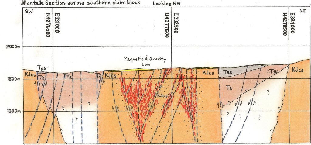
In 2012, Altan Nevada trenched approximately 732 meters over two mineralized zones, collecting 237 chip channel samples. Six trenches reached bedrock, exposing structures with strong sericitic alteration, mesothermal quartz veining, anomalous pathfinder geochemistry and locally elevated gold values; indicating intrusion-related mineralization. Assays included 7.5 m @ 0.490 g/t Au from T-8 and 1.6 m @ 10.15 g/t Au, including 0.6 m @ 25.9 g/t Au from T-12 . These results are encouraging, confirming previously sampled high grade gold values.

image: “Montelle – Yerington District site”

HHH.V