White-horizontal-logo-web 1

Yellow Cone

Targets: Volcano-plutonic hosted copper-gold-silver systems

Area: ~5600 acres, or ~23 km2

Location: Nye County, south-central Nevada, USA

Ownership: 100% owned by Altan Nevada

Reduced-to-pole-magnetic-map-of-the-Yellow-Cone-project-showing-gold-anomalies-associated-with-magnetic-low1
Reduced-to-pole magnetic map of the Yellow Cone project, showing gold anomalies associated with magnetic low

OVERVIEW – LARGE UNEXPLORED SYSTEM LOCALIZED BY MAJOR REGIONAL GEOPHYSICAL ANOMALIES.

The newly-staked Yellow Cone project is a large volcano-plutonic hosted gold-silver-copper system that has seen very little modern-era exploration. It consists of 280 unpatented mining claims and covers an area of approximately 5600 acres or 23 km2. Altan Nevada identified Yellow Cone through regional geophysics as a structurally-controlled magnetic low astride a regional gravity high. The regional gravity feature is associated with a complex structural nexus zone at the southern tip of the Monitor Range.

OVERVIEW – EXCEPTIONAL GOLD, SILVER, COPPER AND PATHFINDER ASSAYS AT SURFACE

An extensive quartz vein system was historically developed through a number of shafts and produced several thousand ounces of gold (part of the Ellendale district) early in the 20thcentury. Recent rock sampling shows highly elevated Au, Ag, As, Cu, Mo, Sb, Se, Te and other elements. Sampling has returned values up to 26 g/t gold, 880 g/t silver, and +5% copper.

YC-Target-Rock-Samples-Geochemical-Characterrization
Click to enlarge
Regional-geologic-map-of-the-east-central-Walker-Lane-mineral-belt-showing-location-of-the-Yellow-Cone-project-and-historic-and-modern-districts
Regional geologic map of the east-central Walker Lane mineral belt, showing location of the Yellow Cone project and historic and modern districts

Pink/red units are Tertiary volcanic and plutonic rocks, brownish units are Paleozoic sedimentary rocks, yellow is Quaternary gravels. Distance from Yellow Cone to Tonopah is approximately 45 km.

GEOLOGY – HOST ROCKS AND STRUCTURE

The project lies along the northeastern edge of the Walker Lane, a major mineral belt which hosts numerous historic and modern epithermal precious-metals mines and districts. Tertiary monzodiorite intrusives underlie most of the property. Paleozoic sedimentary rocks crop out to the south. Post-mineral (?) rhyolite or Quaternary gravels cover much of the property. Prominent EW to WNW-striking high angle fracture sets cross the entire property and appear to reflect the main structural control on mineralization.

GEOLOGY – HYDROTHERMAL SYSTEM

The Yellow Cone project is prospective for disseminated and high grade vein-type epithermal precious metals deposits. The strongly anomalous levels of Cu sampled in outcrop may indicate a high-sulfidation epithermal system, perhaps similar to the nearby Goldfield district (4.2 Moz Au). High sulfidation systems typically contain copper-silver sulfosalts such as enargite. Yellow Cone is approximately 6 kilometers from the Ellendale district, which produced 17,000 tonnes of ore grading 23 g/tonne Au, 185 g/tonne Ag and 0.18% Cu from enargite-bearing quartz veins.

Yellow-Cone-Rock-Sample
Yellow Cone Rock Sample

RECENT WORK – PROJECT IS FULLY PERMITTED FOR PHASE I DRILLING

The Bureau of Land Management has approved a Notice of Intent for roads and drilling for a Phase I drill program at Yellow Cone. Reclamation bonding has been placed and accepted by the Reno BLM office. The project is ready to drill.

image: “Yellow Cone Surface”

TARGETS – MAGNETIC SURVEY INDICATES EXTENSIVE HYDROTHERMAL ALTERATION/MINERALIZATION

Altan Nevada collected 240 rock-chip samples and 1551 soil samples. We have also conducted approximately 17.5 line-km of IP and a magnetic survey. This work defines important features of exploration significance, including a large magnetic low and strong Au, Ag and Cu anomalies. The magnetic survey shows that stronger areas of the low correspond to Au-Ag-Cu anomalies, suggesting that it maps hydrothermal alteration/mineralization. A large magnetic high is present south of the claim block, where there is outcropping skarn.

Reduced-to-pole-magnetic-map-showing-IP-lines-880x1024
Reduced-to-pole magnetic map, showing IP lines

TARGETS – INITIAL IP DATA SHOWS LARGE CHARGEABILITY FEATURE ASSOCIATED WITH AU, AS

The IP survey shows a large, NW trending, high-amplitude chargeability feature in the southern portion of the claim block. This feature is associated with strongly elevated As at its SE end. The NW end of this feature projects into a NE-striking zone of anomalous Au gold values in soil. Much of this area is covered by post-mineral Quaternary gravels.

IP resistivity and chargeability profiles, Line 2. Note major chargeability anomaly
Rock-chip-and-soil-As-geochemistry.-Red-diamonds-are-preliminary-Phase-I-drill-targets.-Dashed-lines-indicate-IP-chargeability-high1-990x1024
Rock-chip and soil As geochemistry. Red diamonds are preliminary Phase I drill targets. Dashed lines indicate IP chargeability high

TARGETS – GEOCHEMISTRY REVEALS LARGE MINERALIZED STRUCTURAL TRENDS

Strong, widespread rock-chip Au, Ag and Cu anomalies are present at the Yellow Cone property. Au values are as high as 26 ppm, Ag is as high as +800 ppm and Cu as high as +5%. Soil geochemistry data show a pronounced WNW trending anomaly near the central part of the project in an area with abundant quartz veining. An image of the Ag:Pb ratio in soil shows a strong NE-trending fabric intersecting the WNW-trending fabric.

Rock-chip-and-soil-Au-geochemistry.-Red-diamonds-are-preliminary-Phase-I-drill-targets.-Dashed-lines-indicate-IP-chargeability-high1-990x1024
Rock-chip and soil Au geochemistry. Red diamonds are preliminary Phase I drill targets. Dashed lines indicate IP chargeability high
Rock-chip-and-soil-Ag-geochemistry.-Red-diamonds-are-preliminary-Phase-I-drill-targets.-Dashed-lines-indicate-IP-chargeability-high1-977x1024
Rock-chip and soil Ag geochemistry. Red diamonds are preliminary Phase I drill targets. Dashed lines indicate IP chargeability high
Rock-chip-and-soil-Cu-geochemistry.-Dashed-lines-indicate-IP-chargeability-high-991x1024
Rock-chip and soil Cu geochemistry. Dashed lines indicate IP chargeability high
Image-of-Ag-or-Pb-ratio-in-soil-with-rock-chip-Au-data-991x1024
Image of Ag/Pb ratio in soil, with rock-chip Au data

WHAT'S NEXT – FIRST ROUND DRILL PROGRAM WILL TEST MINERALIZED STRUCTURES

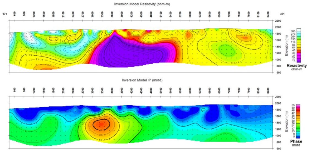
Despite the work carried out to date, the Yellow Cone project is at an early stage. The large chargeability anomaly is open at both ends where it begins to intersect zones of critical geochemical anomalies. Additional IP work is justified to determine the extent of this target. The work to date has, however, defined a large mineralized area sufficiently well to test preliminary conceptual drill targets. These holes will provide tests of important mineralized structures to guide more advanced exploration.

HHH.V